Author:
Giulia Montanari
Citation:
Montanari, G. (2024): Space-Time Paths (by Hägerstrand). In: VisQual Methodbox, URL: https://visqual.leibniz-ifl-projekte.de/methodbox/2023/09/14/space-time-paths-by-torsten-hagerstrand/
Description
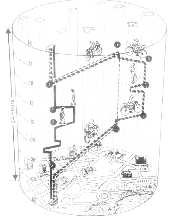
Already in his the article of 1970, which would be later considered the founding document of time geography, the Swedish geographer Torsten Hägerstrand used space-time paths to illustrate his conceptual thoughts on how to integrate the time-scale to geographical thinking. Events ought to be conceptualized in their linearity and sequentiality, individuals were thought of as indivisible and as passing an uninterrupted path in time and space, beginning from their birth until their death.
Illustrating his thoughts in graphs which are base on a section in absolute time and space (like a 24-hour sequence on a local level), these time-geographical paths became a typical visual tool for research that focussed on individuals everyday life activites. They are used to illustrate typical paths of individuals during a day (e.g. an interviewee’s working day) and can also help identify typical restraints and ranges in everyday life.
Problems, or rather aspects to consider, which come up with this tool are the many decisions that have to be made beforehand (what spatial and time-scale is being used; on a 24-hour scale: what stops are taken into account; how many persons are included etc.). These are even more urging if the tool is used as an analytical one rather than for just illustrating purposes. Also problematic is the use of the space-time paths if the research question refers to another spatial concept than the container – in which case the interpretation needs to take the different spatial (and time) concepts into account. And: For people not used to this kind of illustration, the space-time paths are not intuitive to understand and need proper explanation.
Procedure
Step 1: Collection of data (interview, collaboration, diary taken by interviewees)
Step 2: Categorization of activities and places (this step should be the first one, if the researcher asks for a diary)
Step 3: Decision for time and spatial scale
Step 4: Drawing of space-time path
Requirements
The base for drawing the paths is a time and space diary for the individual. It can be reconstructed directly from an interview or be based on a time-space diary an interviewee filled out.
Eventhough the space-time paths can be drawn by hand, to use it in a publication, it is recommended to use drawing software such as InDesign.
There is also a small software, called Daily Life 2011, provided by the Time Geographic Network, Linköping University/Sweden. It can be useful if more than one paths are planned to be drawn and maybe even quantitative data be extracted from the information.
Examples

Image 1: Individual paths of a family, 24 hours (Parkes/Thrift 1980)

Image 2: Individual paths, 24 hours, horizontally displayed (Ellegård/Vilhelmson 2004, Fig 3., 288)

Image 3: Individual path, biographical scale (Mager 2011)
Ressources
References
Ellegård, K. u. B. Vilhelmson 2004: Home as a pocket of local order: Everyday activities and the friction of distance. In: Geografiska Annaler B, 86, 4, S. 281 – 296. https://doi.org/10.1111/j.0435-3684.2004.00168.x
Hagerstrand, T. (1970): What About People in Regional Science? In: Regional Science Association Papers, 24, S. 7–21. https://courses.washington.edu/cee500/What%20about%20people%20in%20regional%20science.pdf
Mager, C. (2011): Heidelberger Nobelpreisträger. In: Meusburger, P.; Schuch, T. (Hg.), Wissenschaftsatlas der Universität Heidelberg, Knittlingen: Bibliotheca Palatina, S. 250–253.


Leave a Reply